
Life after 1982: Michael Jackson’s Thriller and Great Falls Transit
Beau Levine, Volunteer
Public transit is a great mobility-enhancer for cities; the young, old, disabled, and economically disadvantaged gain a sense of autonomy. Unfortunately, Great Falls’ transit history has been rocky at best. The last streetcar ran in 1931, the first bus system closed in 1959, and the second closed in 1961. Great Falls saw no local buses again until 1982, when we got our third and current bus network.
During that period of 21 years between the second and third bus system, there were a series of proposals for a new system in 1977 that would slowly evolve into the current iteration of our bus network.
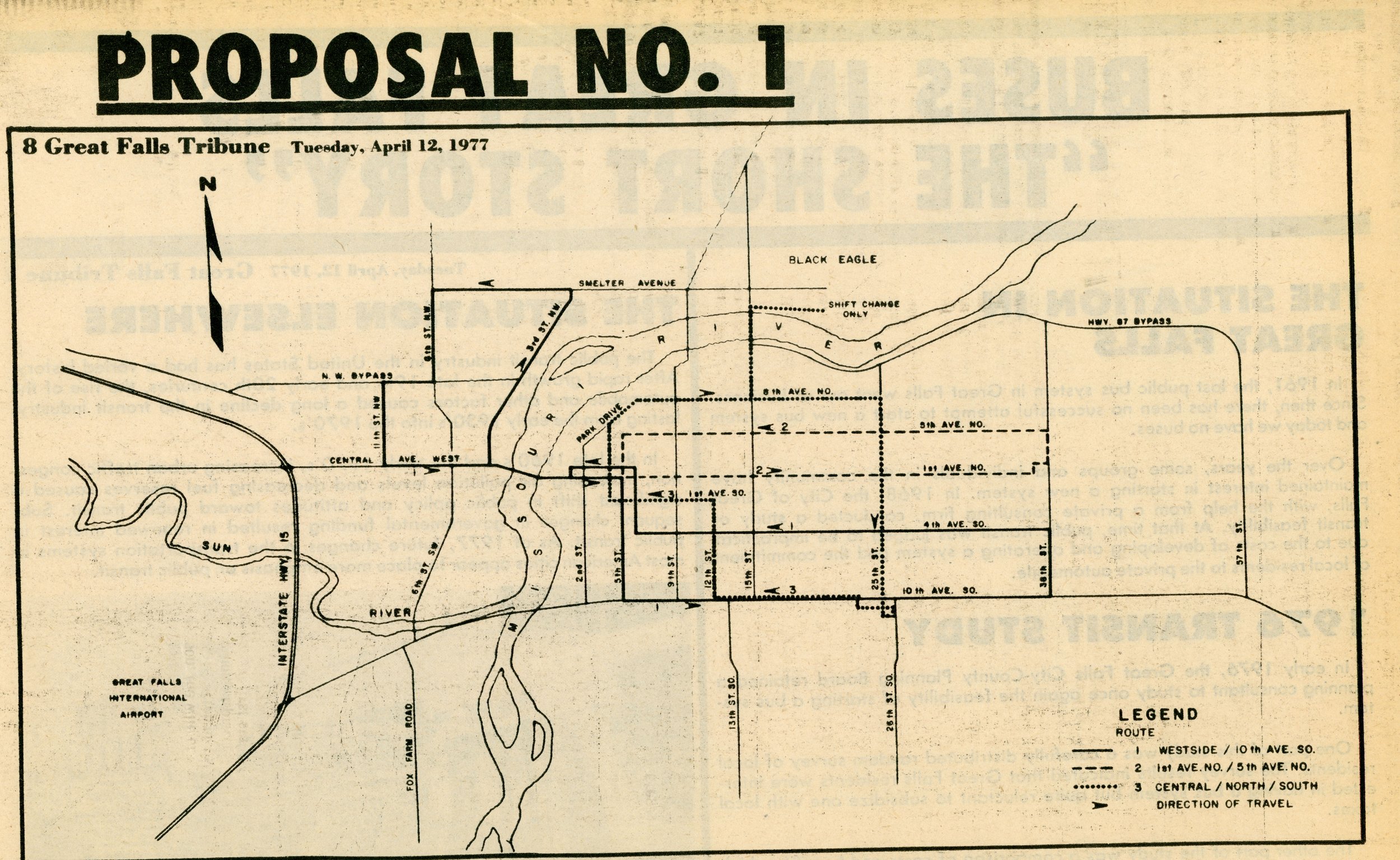
Proposal 1 of the new bus system. All routes terminate downtown. [Great Falls Tribune April 12, 1977]
Route 1: Serves 4th Avenue South and runs a large loop in Northwestern Great Falls
Route 2: Outbound on 1st Avenue North and inbound on 5th Avenue North with the turnaround at 38th Street.
Route 3: Outbound on 8th Avenue North and 25th Street and inbound on 10th Avenue South, 12th Street, and 1st Avenue South. There is a line drawn to Black Eagle labeled “Shift change only”
Proposal 1 featured three routes that covered a lot of ground but may have been inconvenient to ride because every route is a mono-directional loop, rather than the more common model of bi-directional service along one street.
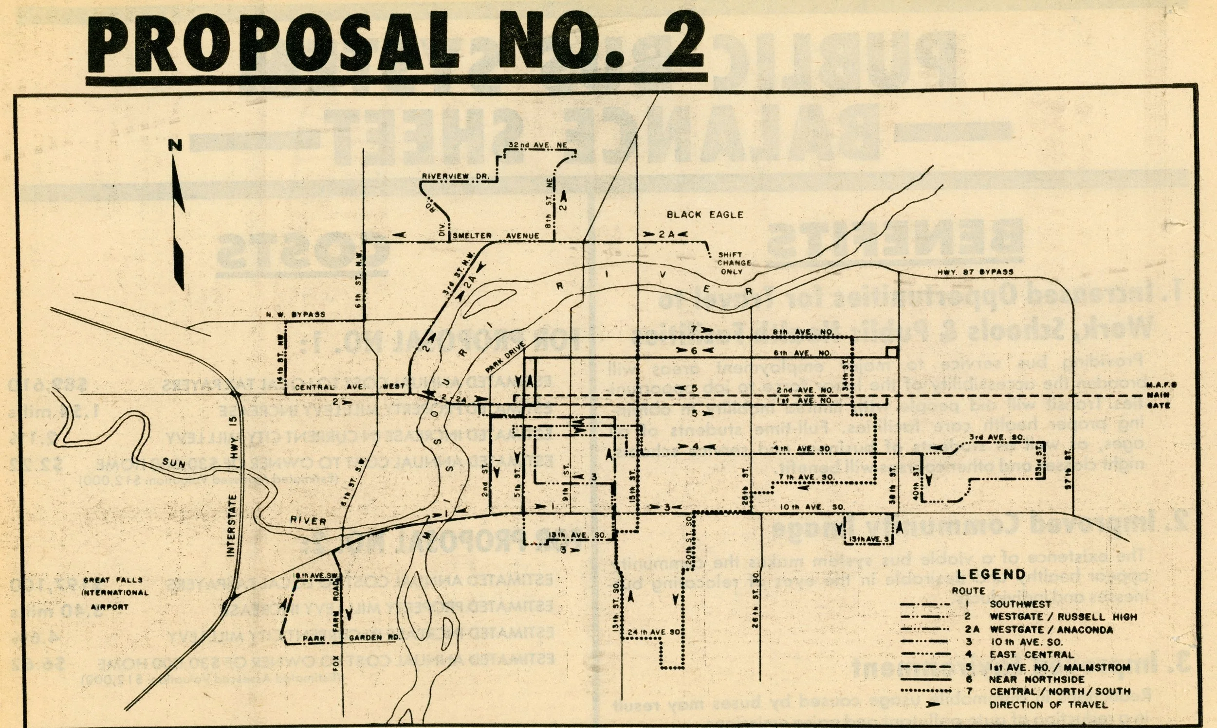
Proposal 2 for a new bus system. All routes except 7 terminate downtown. [Great Falls Tribune April 12, 1977]
Route 1: Covers southwest city and the Fox Farm neighborhood, using the 10th Avenue South bridge to cross the river.
Route 2: Serves northwestern Great Falls via a large loop around the fairgrounds, Westwood shopping center, and North Middle School.
Route 2A: Unlike the loop design of Route 2, this one travels along 3rd Street Northwest and Smelter Avenue to Black Eagle, where there is, again, a branch only for shift changes.
Route 3: Serves 10th Avenue South before turning around shortly before 38th Street
Route 4: Serves 4th Avenue South until it becomes a small loop and finally turns around at 53rd Street.
Route 5: Serves 1st and 2nd Avenue North to Malmstrom AFB
Route 6: Serves 6th Avenue North until 38th Street
Route 7: Serves central Great Falls in a clockwise loop. The route’s borders are shaped by 15th Street, 34th Street, 8th Avenue North, 24th Avenue South.
Proposal 2, on the other hand, is much more like what we have today. Compared to Proposal 1, this has seven routes and is, frankly, the better option. However, there is still one oddity: route seven, being the only route to not travel downtown. This model is effective for travel on public transit networks, as it allows one-seat journeys to be made (journeys not requiring a transfer).
However, neither of these proposals came to pass exactly as they were, so on February 8, 1982, when Great Falls Transit’s (GFT) bus service launched, we got the route map below. Many things still look strange to riders familiar with the contemporary bus system. For one, the route numbers are all different. This was true in the proposals, but those were liable to change anyhow, and it’s much more noticeable in color. Additionally, there are only 6 routes; no loop route made it out of planning.
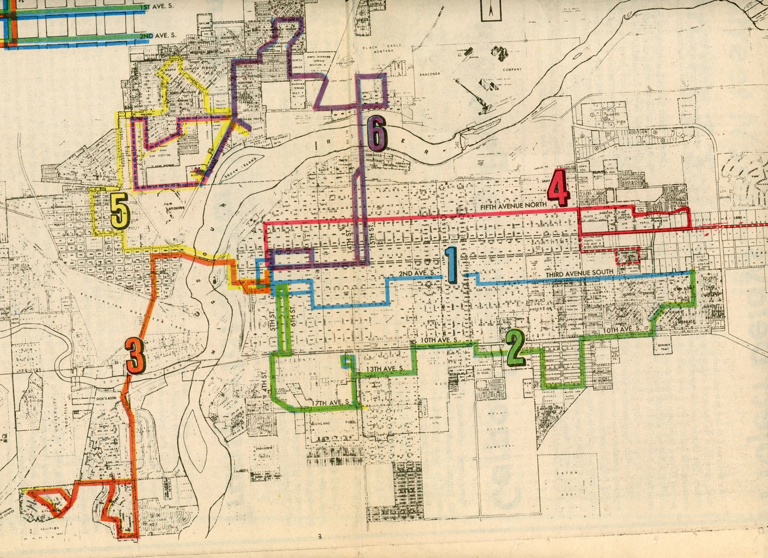
The initial Great Falls Transit bus system launched in 1982. [Great Falls Tribune February 8, 1982]
Route 1, blue: Central Great Falls
Route 2, green: South-Central Great Falls
Route 3, orange: Southwestern Great Falls
Route 4, red: North-Central Great Falls. The dotted lines on right end are an extension to Malmstrom Air Force Base and Easterseals. These spurs were on a two-month trial basis, and buses would alternate between these two eastern termini. Eventually, MAFB was chosen, and Easterseals was no longer served.
Route 5, yellow: Western Great Falls
Route 6, purple: Northwestern Great Falls
There’s a hidden quirk to this system that can’t be seen on the map: You can only board or depart on even-numbered blocks. This, however, didn’t apply to streets with names instead of numbers. Today’s bus system uses a flag-stop system, meaning you can board from any block.
It’s worth noting that even from the start, the routes still seem to be in connected pairs of two for operation. For those who are not familiar, when Route 1 reaches the transfer center today, it becomes Route 2, and vice versa. In this system, 1 and 2, as well as 5 and 6, meet at both ends of their routes, while 3 and 4 presumably just turned around at the end and swapped numbers downtown only.
Speaking of downtown, transfers between routes looked very different from today. The downtown Bus Depot could not be used because it was occupied by Greyhound until 1994. Buses lined up on 4th Street between 1st Avenue South and North, so passengers waited outside where it could get very cold in the winter. However, there were amenities: Two 10-person bus shelters and color-coded poles for passengers to know where their bus would park.
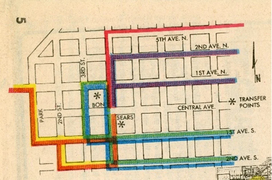
A zoomed-in map of bus routes downtown. Notice how the paired routes join downtown. Asterisks mark the side of the street where buses lined up on 4th Street. [Great Falls Tribune February 8, 1982]
Buses lined up on 4th Street, where passengers could easily transfer between routes [Great Falls Tribune October 1, 1982]
A 10-person bus shelter installed downtown. [Great Falls Tribune April 7, 1983]
On October 2, 1982, Saturday service launched alongside the Central route’s move to Central Avenue (it was previously on 3rd Avenue South).
In 1996, the system saw a massive overhaul to serve new areas of the city. To start with, routes attained their current colors, numbers, and general shapes despite looking a little misshaped to current riders.
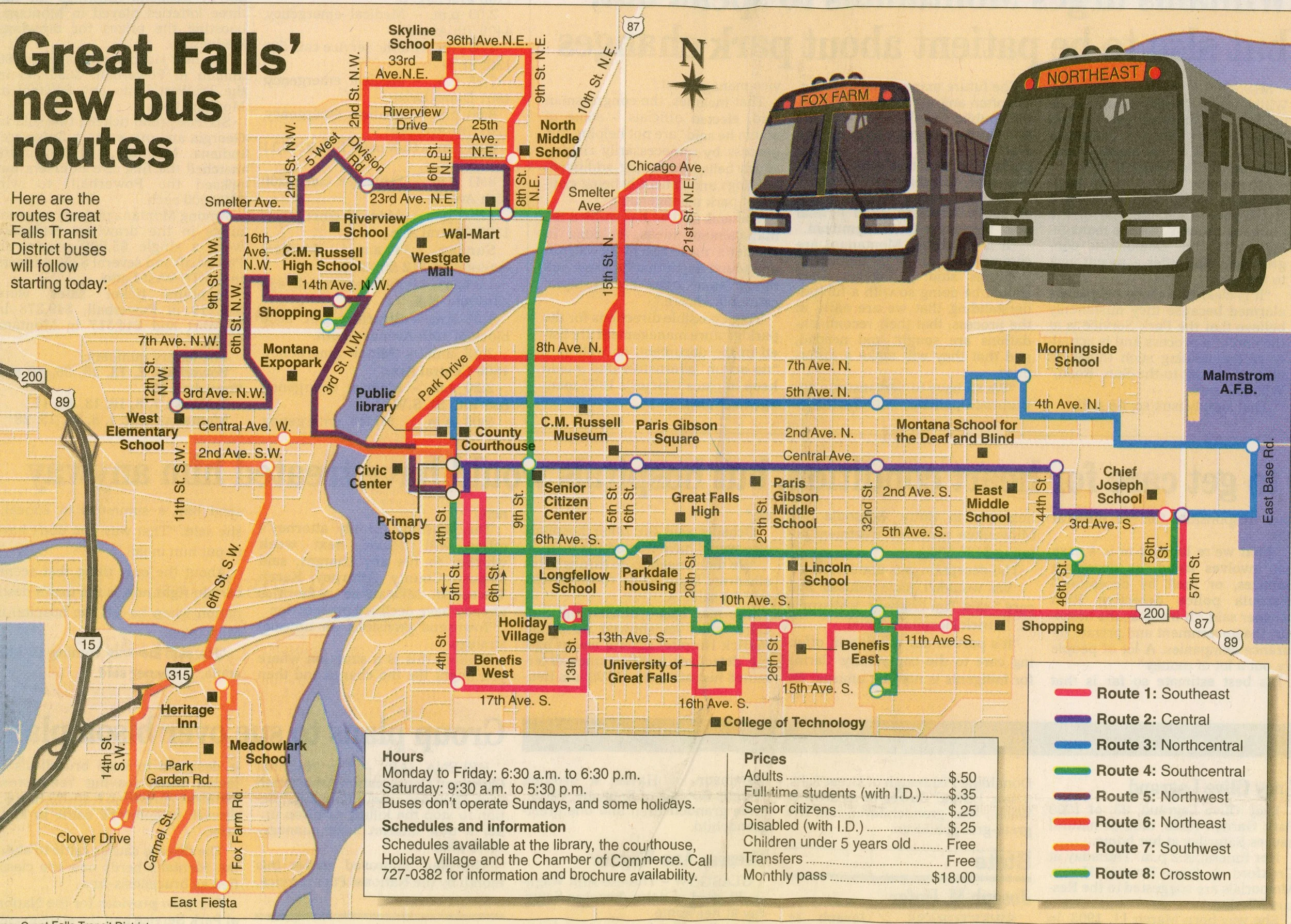
A 1996 system map of bus service provided by Great Falls Transit. Route numbers and colors are completely different from previous iteration. [Great Falls Tribune August 26, 1996]
Route 1, pink, southeast
Route 2, purple, central
Route 3, blue, northcentral
Route 4, green, southcentral
Route 5, purple, northwest
Route 6, red, northeast
Route 7, orange, southwest
Route 8, lime, crosstown
A seventh and eighth route were also added, one ran along 6th Avenue South, while the other ran along 10th Avenue South and 9th Street to Westwood Shopping Center, where Sam’s Club and North 40 are, via 3rd Street Northwest. This route, Crosstown, is the first and only route to not serve downtown.
When it comes to transfer centers, Routes 1-4 gathered outside of Chief Joseph Elementary School at their eastern termini, since Walmart East didn’t exist yet and it was equal distances from the northern and southern routes. Downtown transfers remained on the street, even though Greyhound no longer occupied the Bus Depot, Great Falls Transit had not yet acquired it.
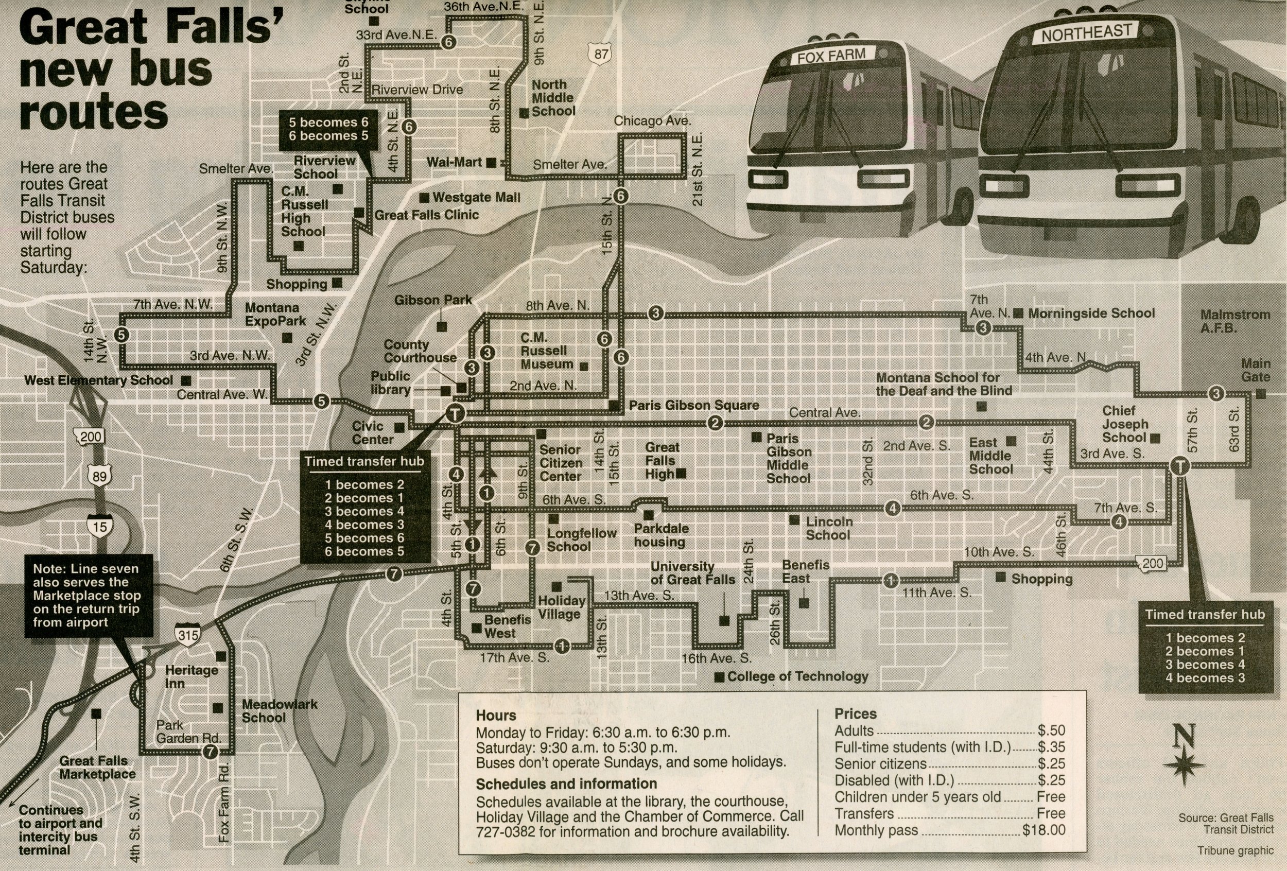
A map of Great Falls public bus service in 1999. Routes retain same numbers and colors as 1996 map. Route 8, Crosstown, is absent. [Great Falls Tribune May 17, 1999]
In 1999, this new map, above, hit the scene. Route 3 was moved to 8th Avenue North because of higher speeds and fewer drainage ditches, and other routes were slightly adjusted to their current position. Unfortunately, Route 8 was axed due to excruciatingly low ridership. But there’s much better news: Route 7. This route goes to the airport, which served a very important transit connection for air and intercity bus travel. Downtown transfers would move to the downtown bus depot very soon, as Great Falls Transit acquired and refurbished it in 2000.
And, finally, for those who read this article having no idea what the modern network of Great Falls Transit looks like, here it is. No further information could be found as to why Route 7 stopped serving the airport.
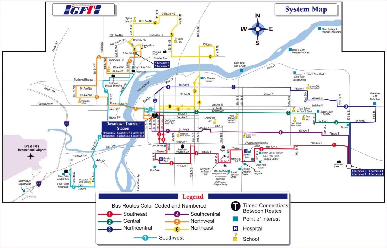
The current map of Great Falls Transit’s bus service. [https://www.gftransit.com/routes#TRIPPLANNER]
As for the future, Great Falls Transit has expressed interest in moving to a fixed-stop system (where you cannot board from any block), increasing frequencies on Routes 1 & 7, and potentially adding an eighth route that looks a lot like Crosstown, except it wouldn’t cross the river.